Showing posts with label route. Show all posts

Monday, 7 March 2011

Bicester ice-cream ride


start: Oxford, Marston [SP530079]
finish: Oxford, Marston
distance: 41 km

When in France last year, we found these great ice-cream cafes called Amorino. And to my surprise they have a little shop in Bicester as well! Well worth a visit, and this bicycle route takes you there and back. It includes a few hundred metres of very bad road surface (which stops cars using it as a rat run from the A34), and a great gravel road on your way back. Both sections I've marked in red on the map.

Route map:

This route is also published on MapMyRide

Sunday, 1 August 2010

Chilterns beauty

start: Oxford, Marston [SP530079]
finish: Oxford, Marston
distance: 112 km

So far my favourite bicycle route in the Chilterns. The first 30 km are an easy warm-up. Then there's the beautiful long climb following the old A40 up the Chilterns escarpment. A few kms past Christmas Common you dive down again on a narrow road to Britwell Salome. You can easily reach a speed of 60 km/h or more on this descent. After Ewelme it goes back up again and this part of the route, past Cookley Green and Russell's Water is particularly pretty. The climb to Bix is very steep and after that it's another 45 kms of rolling hills taking you back to Oxford.

Route map:
Chilterns beauty, elevation profile This route is also published on MapMyRide

Friday, 19 March 2010

Witney Stonesfield loop

near Water Eatonstart: Oxford, St Giles [SP512065]
finish: Oxford, St Giles
distance: 56.2 km

If you're not ready for the 70 km route through Witney yet, then this route is a nice alternative. The most interesting and surprising section is from Gosford (near Kidlington) through Water Eaton to Oxford. It's mainly a concrete road but for a few hundred metres you're cycling on a grassy track. It gives you that spring-classic feeling!

Route map:
Witney Stonesfield loop, elevation profile This route is also published on MapMyRide

Thursday, 4 February 2010

Kiddington quiet road

start: Oxford, Marston [SP530079]
finish: Oxford, Marston
distance: 66 km

I created this route mainly to guide you to a very quiet, car-free, good quality road between (Over) Kiddington and the B4437. On the Ordnance Survey map this road is drawn white, but it is perfectly suitable for road bikes. One of my favorite few km's in Oxfordshire.

Route map:
Kiddington quiet road, elevation profile This route is also published on MapMyRide

Sunday, 11 October 2009

Oxford to Quainton

Windmill in Quainton
start: Oxford, Old Marston
finish: Oxford, Old Marston
distance: 82 km

I did this route last week because it was such a nice autumn day. I had never heard of a village like Quainton before and it turns out they have a very nice windmill there. The route is pretty flat overall.

Route map:
Oxford to Quainton, elevation profile

Monday, 4 May 2009

Lord of the Oxford Ring

start: Oxford, Wolvercote Roundabout (or anywhere else on the ring, convenient for you)
distance: 25.2 km

Not the most scenic route, but still nice to do. The route follows the ring road around Oxford as close as possible. Most of the time you're riding on bike paths seperated from the busy car traffic, with a few short exceptions of which the Botley interchange is the most hazardous. I explored this route last winter and really enjoyed it.

Route map:
This route is also published on MapMyRide

Wednesday, 1 April 2009

Boars Hill

View at Oxford from Boars Hillstart: Oxford, St Giles [SP512065]
finish: Oxford, St Giles
distance: 27.2 km

This circle over Boars Hill is a nice route for an evening after work, or at the start of the cycling season. From the top of Boars Hill, you get a good view over the city of Oxford.

Route map:
Boars Hill, elevation profile This route is also published on MapMyRide

Sunday, 8 February 2009

Oxford to Leeds

start: Oxford, Jericho [SP505071]
finish: Leeds, Yeadon [SE208403]
distance: 361 km

I few years ago I had to go to Yeadon for work, which is close to Leeds, and decided to cycle there in a weekend. To avoid any serious hills I chose my route East of the Pennines, which worked out very well. It took me three days in the end.

Route map:

Thursday, 12 June 2008

Oxford to London

start: Oxford, The Plain [SP522060]
finish: London, Victoria Station
distance: 98 km

Cycling to London is quite special. This route follows the A40 across the Chilterns and tries to avoid busy roads as much as possible. Further into London the route is along the tow path of the Grand Union Canal for a few miles and brings you eventually to the bus stop near Victoria Station of the Oxford Tube bus service which can bring you and your bicycle back to Oxford. Well, that's what I did anyway.

Route map:
Oxford to London, elevation profile This route is also published on MapMyRide

Monday, 26 May 2008

Chilterns from Watlington

start: Watlington [SU690944]
finish: Watlington
distance: 65 km

For this bike ride we drove to Watlington (Oxfordshire) to skip the flat area between Oxford and the Chilterns. Watlington lies at the foot of the Chilterns and the climb up Christmas Common should warm you up nicely. The route takes you up some pretty hard climbs and beautiful narrow roads.

Route map:
Chilterns from Watlington, elevation profile This route is also published on MapMyRide

Wednesday, 16 April 2008

Brill and Ashendon

start: Oxford, Marston [SP530079]
finish: Oxford, Marston
distance: 59.5 km

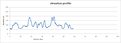
This is quite a hilly route. As you can see on the elevation profile, there are hardly any flat bits.

Route map:
Brill and Ashendon, elevation profile This route is also published on MapMyRide

Wednesday, 31 October 2007

White Horse and Wayland's Smithy

White Horse from the airstart: Oxford, St Giles [SP512065]
finish: Oxford, St Giles
distance: 77 km

The White Horse of Uffington is thought to be the oldest hill figure in Britain, dating back more then 3000 years. Cycling there, through the Vale of the White Horse, is very flat until you reach the ridge way. It's a challenging climb but once you're at the top there are, apart from the horse, two more sites worth visiting in close proximity: Uffington Castle with it's banks and ditches surviving, and Wayland's Smithy, a neolithic long barrow. (reproducted photography ; Morris Marples, 'White Horses and other Hill Figures', Alan Sutton, 1981).

Route map:
White Horse and Wayland's Smithy, elevation profile This route is also published on MapMyRide

Thursday, 18 October 2007

Dorchester and Abingdon

start: Oxford, The Plain [SP522060]
finish: Oxford, The Plain
distance: 43 km

Very flat route in the Thames Valley. You cross the river at Dorchester which involves following a footpath for a short stretch, the turn-of is easy to miss! Furthermore there are some bits on actual dedicated cycle path, yes they do exist in Oxfordshire.

Route map:
Dorchester and Abingdon, elevation profile This route is also published on MapMyRide

Friday, 12 October 2007

Banbury and back

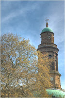
St Mary's Church in Banburystart: Oxford, St Giles [SP512065]
finish: Oxford, St Giles
distance: 90.3 km

Banbury Road is well known in Oxford and most people I meet think Banbury is just down the road. But actually Banbury is not that close but worth a visit. Cycling down Banbury Road will bring you eventually in Banbury, but it's an unpleasant and dangerous ride with fast moving cars and trucks on the same road. This route is much quieter and leads you through beautiful Oxfordshire villages, and Banbury of course. When it's too far you can always take the train back instead!

Route map:
Banbury and back, elevation profile This route is also published on MapMyRide

Thursday, 4 October 2007

West of Oxford

start: Oxford, St Giles [SP512065]
finish: Oxford, St Giles
distance: 54.7 km

Mainly flat cycling route except for a little bump at the end, called Boars Hill. The first 12 km can be unpleasantly busy with cars, but as soon as you leave the B4449 onto the single track road, it's much quieter. Another very nice stretch of single track road between Witney and Stanton Harcourt has long escaped my attention, but is very worthwhile. Even if your bicycle doesn't have any gears this route shouldn't be a problem.

Route map:
West of Oxford, elevation profile This route is also published on MapMyRide

Saturday, 29 September 2007

Witney and Chadlington

start: Oxford, St Giles [SP512065]
finish: Oxford, St Giles
distance: 71.2 km

A nice route from Oxford to the edges of the Cotswolds. There's some fantastic scenery of which the road through Wychwood Forest is one of my favorite.

Route map:
This route is also published on MapMyRide

Wednesday, 26 September 2007

Brill and back

Brill Windmillstart: Oxford, Marston [SP530079]
finish: Oxford, Marston
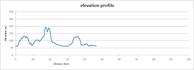
distance: 46.1 km

This cycling route is a favorite of mine. It takes you to Brill, a nice village on top of a hill with a pretty windmill. There are a few climbs of which the one between Boarstall and Brill is the hardest. If you feel like stopping at a teashop I recommend the one at Waterperry Gardens.

Route map:
Brill and back, elevation profile This route is also published on MapMyRide

Sunday, 16 September 2007

Around Otmoor

start: Oxford, The Plain [SP522060]
finish: Oxford, The Plain
distance: 36.2 km

This easy cycling route will take you around the low lands of
Otmoor, North of Oxford. The route is mainly flat with two minor
climbs, one getting into Elsfield and the other in Horton-Cum-Studley.
I recommend this route for beginners or for anyone who is looking for
an easy start of the cycling season. There are at least three pubs along this route so there's no need to get thirsty.

Route map:
Around Otmoor, elevation profile
This route is also published on MapMyRide