Monday 7 March 2011
Bicester ice-cream ride
start: Oxford, Marston [SP530079]
finish: Oxford, Marston
distance: 41 km
When in France last year, we found these great ice-cream cafes called Amorino. And to my surprise they have a little shop in Bicester as well! Well worth a visit, and this bicycle route takes you there and back. It includes a few hundred metres of very bad road surface (which stops cars using it as a rat run from the A34), and a great gravel road on your way back. Both sections I've marked in red on the map.
Route map:
This route is also published on MapMyRide
Sunday 19 September 2010
Oxford to Avignon
start: Oxford, UK
finish: Avignon, France
distance: 1160 km
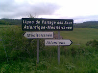
It took me eleven days to cycle from Oxford to Avignon, in the South of France. Here's the route including the campsites. I crossed the Channel from Portsmouth to Caen on the ferry and headed for the Loire at Orléans. Then followed this river upstream for a few days to avoid serious hills, for as long as possible. On the 10th day I went over the 1300 meter high watershed between Atlantic and Mediterranean, at the source of the river Ardeche. It was a fantastic tour and the last day through the Gorge d'Ardeche was an amazing finale. I came back on the train (in case anyone wonders).
Route map:
View Larger Map including campsites
Choose elevation profile to view:
Sunday 1 August 2010
Chilterns beauty
start: Oxford, Marston [SP530079]
finish: Oxford, Marston
distance: 112 km
So far my favourite bicycle route in the Chilterns. The first 30 km are an easy warm-up. Then there's the beautiful long climb following the old A40 up the Chilterns escarpment. A few kms past Christmas Common you dive down again on a narrow road to Britwell Salome. You can easily reach a speed of 60 km/h or more on this descent. After Ewelme it goes back up again and this part of the route, past Cookley Green and Russell's Water is particularly pretty. The climb to Bix is very steep and after that it's another 45 kms of rolling hills taking you back to Oxford.
Route map:
This route is also published on MapMyRide
Friday 19 March 2010
Witney Stonesfield loop
start: Oxford, St Giles [SP512065]
finish: Oxford, St Giles
distance: 56.2 km
If you're not ready for the 70 km route through Witney yet, then this route is a nice alternative. The most interesting and surprising section is from Gosford (near Kidlington) through Water Eaton to Oxford. It's mainly a concrete road but for a few hundred metres you're cycling on a grassy track. It gives you that spring-classic feeling!
Route map:
This route is also published on MapMyRide
Labels:
bletchingdon,
cycling,
gosford,
oxford,
route,
stonesfield,
water eaton,
witney
Thursday 4 February 2010
Kiddington quiet road
start: Oxford, Marston [SP530079]
finish: Oxford, Marston
distance: 66 km
I created this route mainly to guide you to a very quiet, car-free, good quality road between (Over) Kiddington and the B4437. On the Ordnance Survey map this road is drawn white, but it is perfectly suitable for road bikes. One of my favorite few km's in Oxfordshire.
Route map:
This route is also published on MapMyRide
Labels:
bletchingdon,
cycling,
islip,
kiddington,
middle barton,
oxford,
route,
somerton
Sunday 11 October 2009
Oxford to Quainton
Monday 4 May 2009
Lord of the Oxford Ring
start: Oxford, Wolvercote Roundabout (or anywhere else on the ring, convenient for you)
distance: 25.2 km
Not the most scenic route, but still nice to do. The route follows the ring road around Oxford as close as possible. Most of the time you're riding on bike paths seperated from the busy car traffic, with a few short exceptions of which the Botley interchange is the most hazardous. I explored this route last winter and really enjoyed it.
Route map:
This route is also published on MapMyRide
Subscribe to:
Posts (Atom)